Plat of the Town of El Paso
Plano del Pueblo de El Paso
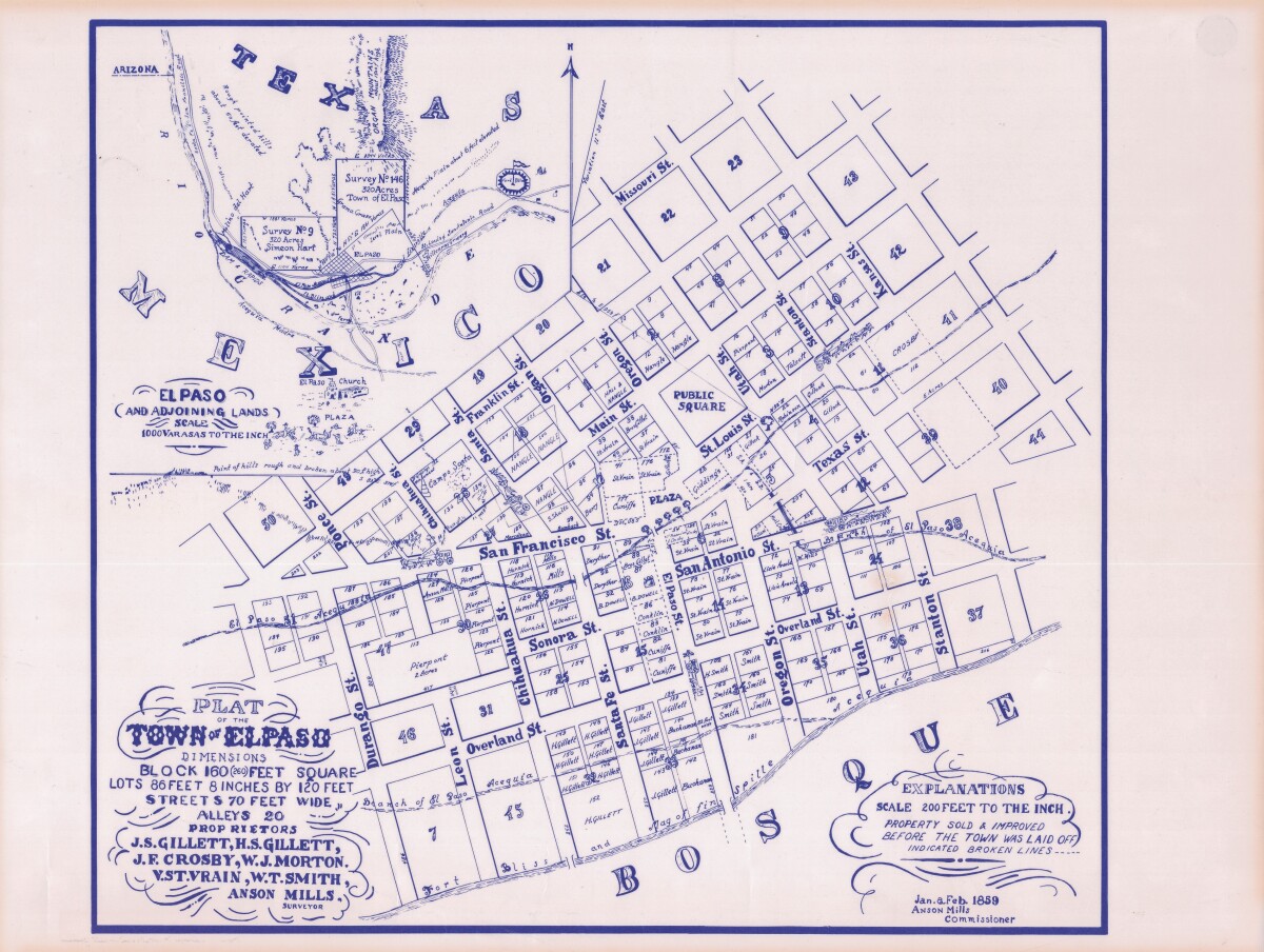
Plat of the Town of El Paso
Plat map of the Town of El Paso (Texas); includes dimensions for lots, streets, alleys; an inset with topographical representations; Scale of adjoining lands is 1000 to the inch; Explanations scale is 200 feet to the inch; Survey details and Acequia (canal) lines shown.
Report this entry
More from the same community-collection
Photography by Heber A. Nickolath
Pasos Urbanos: A Photographic Narrative of Downtown Borderland ...
Photography by Heber A. Nickolath
Pasos Urbanos: A Photographic Narrative of Downtown Borderland ...
Photography by Heber A. Nickolath
Pasos Urbanos: A Photographic Narrative of Downtown Borderland ...
Photography by Heber A. Nickolath
Pasos Urbanos: A Photographic Narrative of Downtown Borderland ...
Photography by Heber A. Nickolath
Pasos Urbanos: A Photographic Narrative of Downtown Borderland ...
Photography by Ronald Henry Wells
Pasos Urbanos: A Photographic Narrative of Downtown Borderland ...
Photography by Ronald Henry Wells
Pasos Urbanos: A Photographic Narrative of Downtown Borderland ...
Photography by Ronald Henry Wells
Pasos Urbanos: A Photographic Narrative of Downtown Borderland ...
Photography by Ronald Henry Wells
Pasos Urbanos: A Photographic Narrative of Downtown Borderland ...
Photography by Ronald Henry Wells
Pasos Urbanos: A Photographic Narrative of Downtown Borderland ...
Photography by Omar Zuniga Renteria
Pasos Urbanos: A Photographic Narrative of Downtown Borderland ...
Photography by Rigoberto R De La Mora
Pasos Urbanos: A Photographic Narrative of Downtown Borderland ...
Photography by Rigoberto R De La Mora
Pasos Urbanos: A Photographic Narrative of Downtown Borderland ...
Photography by Rigoberto R De La Mora
Pasos Urbanos: A Photographic Narrative of Downtown Borderland ...
